What is WebShare and why is it such a great asset after any measured survey?
At LA Surveys, we invest in state-of-the-art technology in order to ensure we are always providing market-leading service and that our surveys not only produce the most accurate, reliable and user-friendly information, but crucially make that information available to anyone who will benefit from it.
A great example of this is our investment in FARO’s WebShare platform: an online repository for the processed point cloud data and panoramic photography that our scanners capture during every survey.
Who is FARO?
FARO is the leading global source for 3D measurement, imaging and realisation technology. For 40 years, FARO has provided industry-leading technology solutions that enable customers to quickly and easily measure their world, and then use that data to make smarter decisions faster. FARO is a pioneer in bridging the digital and physical worlds through data-driven reliable accuracy, precision and immediacy.
FARO Sphere and WebShare
FARO Sphere is their hub for all of the data collected at a survey, accessible on a web browser in real-time. WebShare is a small branch of the FARO Sphere ecosystem, which enables us to share scanned projects with clients and collaborators online. WebShare works in any browser; no other software is needed.
FARO Sphere Ecosystem
Privacy, security & two-factor authentication
LA Surveys stores all of the digital data obtained during the course of our surveys on our secure server located in our offices. After processing, part of that data is uploaded to our private online WebShare platform. For security, we require all of our WebShare accounts to have a secure 16-digit password and have two-factor authentication enabled. One secure account will always be shared with the client, and any additional accounts, e.g. for other design team members, will be created only with the client’s written permission and will feature the same security level (16-digit password and two-factor authentication).
What are the tools available in WebShare?
Access to one of our surveys’ WebShare page is always available within a week of the survey, often less. This allows our clients and collaborators to access and view data very soon after the survey, and puts at their fingertips a multitude of tools that enable them to progress early aspects of their design while the survey BIM model and drawings are prepared.
Here are some of the most useful tools available on WebShare:
1. Overview Map
This gives users an overview plan of the scanned building, identifying each scan location. Depending on the level of zoom, these locations might be shown as a cluster.
WebShare overview map
2. Element measurement
WebShare allows users to measure distances in a plan or a photo, thus eliminating the need for future site visits in case additional measurements are needed.
Example of measuring the length of a wall on the overview map
Example of measuring the length of the same wall on a panoramic photo
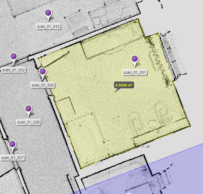
3. Area measurement
Like the measurement tool, the area tool enables users to measure areas, not only on plan but also in the photographic view because the point cloud data is always there behind every 360° photo.
Example of area measuring the length of a wall on the overview map
4. Annotation
The annotation tool is fantastic for adding any necessary mark-ups in WebShare, either as an aide-memoire or to communicate something on the go, such as in this instance the location and sizes for opening up works needed.
Example of annotating zones or items
5. Clipping boxes
Because the point cloud data is behind every WebShare file, anyone can create cross-sections through the 3D point cloud model using “clipping boxes”. This creates a 3D section through the point cloud model whilst also retaining all the annotations previously made in WebShare.
Example of a clipping box through the point cloud
6. View sharing
Sharing the url hyperlink from any view in WebShare will share that precise view, including zoom and rotation, with whomever it is sent to.
Conclusion
By making the point cloud and photographic data behind all of our surveys available online to anyone who needs access to it, LA Surveys extract maximum value from our scans. As Architects ourselves, we know just what a hugely valuable resource this is, not just in the early stages of a renovation project but throughout its whole life. One of the reasons we established LA Surveys as an arm of our architecture business, Lees Associates, was to help close that gap between the survey information recorded and what was provided to us. But it is not just us who benefit; other design consultants, and indeed contractors, who work alongside us on our architecture projects consistently find the data we provide extremely useful too.


